I came in at 7.30 am this morning and my flight out to Johannesburg is only at 10 pm. – so I checked into the Airport Sheraton for a day room. It was not cheap (€150), but completely worth it. As for my connection in Toronto – I had to hustle to make it since I had to go through customs and come back in through security (not clear to me why, maybe because I planned to switch airlines in Frankfurt). Here are pictures from Toronto and from Frankfurt, unfortunately all from indoors, but hey – best to stay inside since it’s pretty chilly outside in both these cities, this time of year.
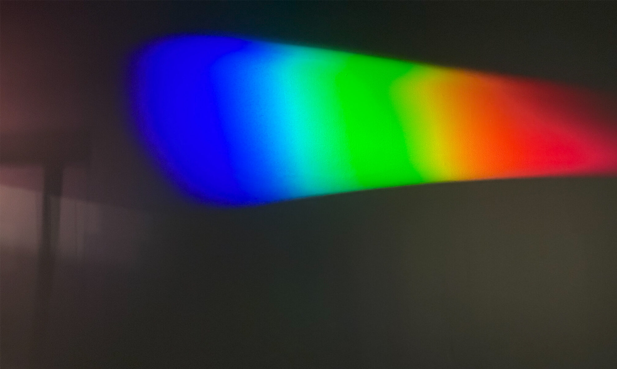
The colored rings inside this giant skylight at Toronto’s Pearson International airport are mesmerizing.Lots of turquoise Air Canada planes with the maple leaf on the tail. I arrived in an Embraer jet from Seattle, and we took a Boeing 777 across the Atlantic to Frankfurt.This giant indoor artwork is at the boarding gate in E terminal in Toronto. Seattle has similar piece but as outdoor art, in Olympic Sculpture Park in downtown Seattle.This is 7.30 am in the morning in Frankfurt. The airport is on my left and I am walking across the skybridge to the Airport Sheraton to catch forty winks (quite a bit more than forty winks, actually). There is still snow on the ground from Monday, but it’s all clear for tonight, so there should not be any delays.Hansel and Gretel (or the witch’s) gingerbread house in the lobby of the Sheraton.This is early Tue evening and I am back in the terminal for the flight out to Johannesburg at Tue night at 10 pm.I like these sharply dressed ‘birds’ on a billboard inside the airport .. even though it was not clear to me what they were advertising!This is at the entrance of Z terminal where we will take off from. Looks the the theme for the decorations is ‘World Fairs’, since there a Shanghai Pearl Tower (2010), a Seattle Space Needle (1962) and the ‘Atomium’ from Brussels (1958). Oh, and the Eiffel Tower which was the entrance arch to the 1889 World Fair in Paris.
I am all re-assembled after the TSA security check – cell phone, watch, belt, shoes, jacket. A little earlier at the check-in counter I ran into a little obstacle. The Air Canada agent said ‘Your yellow fever vaccination documentation, please’ .. this after staring at her monitor for a few minutes (you just know something is up). Of course I did not have one. I was not even checked in yet – booked the ticket through United Airlines, and I found out last night that Air Canada allows on-line check-in from some US cities, but not from Seattle. Anyway – I said ‘Well, I travel to South Africa every year and it’s never been a requirement’ before another agent came to my rescue and confirmed that it’s just a guideline and the traveler’s responsibility.
What is yellow fever anyway? It’s a viral infection transmitted to humans by the bite of an infected mosquito.The majority of persons infected with yellow fever virus have no illness or only mild illness, but some 15% of cases progress to a severe form that can cause jaundice and bleeding and organ failure. Darfur in Sudan has one of Africa’s worst epidemics in decades, with a total of 732 cases and 165 deaths.
Here is the Atlanta-based Centers for Disease Control’s map of yellow fever areas in sub-Saharan Africa. It says ‘No Risk’ for South Africa.
I am taking off for Frankfurt Monday morning for a Tuesday morning arrival there local time. Then on Tuesday night I will continue south to Cape Town via Johannesburg. Yes, it’s a lot of stops! but I managed to get a business class seat on most of the segments, courtesy of United Airlines miles. (Will I ever get myself to fly coach again all the way on these long international routes? I hope so). The other thing to do to prepare these days is to load the smartphone apps for the airlines you will fly on, and even the airports you will visit, onto your phone before you leave. That way you have the updated flight information and airport information handy for the whole trip. So for me it’s Air Canada to Toronto and Frankfurt, then Lufthansa to Johannesburg, and South African Airways to Cape Town.
Here are the gory details of the trip stops and flight times. I am breaking it in two with a little layover in Frankfurt, just enough to catch some sleep in a day hotel, and then I will continue to Cape Town.A map of a new airport’s layout is always handy. I have connected through Frankfurt airport before, but I don’t have a photographic memory !It’s winter time, and so there is always the possibility of snow to delay one’s departure and time. Frankfurt does not have snow in its forecast for the next few days, fortunately.
This is on the way in to work on Monday, a little later than usual so the sun was just up high enough to color the sky above the snow-capped mountains a beautiful blue. We’re in Ogden on Wall Avenue (with a strange familiar tone to it because of Wall Street?), one of the main north-south avenues.
‘Avenue’ also makes me think of the ‘classic’ Electric Light Orchestra song ‘The Way Life’s Meant To Be’ :
Well, I came a long way to be here today
And I left you so long on this avenue
And here I stand in the strangest land
Not knowing what to say or do
As I gaze around at these strangers in town
I guess the only stranger is me
And I wonder (yes, I wonder)
Yes, I wonder (oh, I wonder)
Is this the way life’s meant to be?
Salt Lake City is a small airport and it’s very convenient not to have to catch a shuttle bus to a rental car location away from the airport. This picture is from Sunday night. I had just exited from the baggage claim and the rental car counters and garage are on my left. The snowflake decorations offer a little chilly cheeriness against the winter’s dark.
I was reading this Bloomberg Businessweek article with the provocative headline at the airport on Thursday night. Read it here ! http://www.businessweek.com/articles/2012-11-18/how-airport-security-is-killing-us From the article – ‘To make flying as dangerous as using a car, a four-plane disaster on the scale of 9/11 would have to occur every month, according to analysis published in the American Scientist. People switching from air to road transportation in the aftermath of the 9/11 attacks led to an increase of 242 driving fatalities per month – which means a lot more people died on the roads as an indirect result of 9/11 than died from being on the planes on that terrible day.
[Picture from Wikipedia]. State route UT-39 runs from Ogden out to the Great Salt Lake and back.Here’s the scenery next to UT-39 as we go back to Ogden on Monday afternoon. The snow caps on the mountains are smaller than normal for this time of year. The ski resorts are all open now, but most only has limited runs and are running their snow-making machines to get by until there is more snow.
We take state route UT-39 from the hotel in Ogden to the factory next to the Great Salt Lake where we are doing our project. Utah is nicknamed the ‘Beehive State’, hence the beehive on the road signs. And the name Utah is derived from the name of the Ute tribe, which means ‘people of the mountains’. Speaking of mountains, it has not snowed much since I first arrived at the Salt Lake City airport two weeks ago.
This is Sunday night at the gate in Seattle airport on the way to Salt Lake City. I am sitting in the exit row right up front in the coach section of the Boeing 757. My seat cost me $19 extra but it is completely worth it to me. As the picture shows, we have the most legroom of anyone in the plane! Are we willing and able to operate the door in an emergency? The stewardess asked. Absolutely – we will be the first ones out the door, we assured her.
My flight into Seattle from Salt Lake City late Thu night was fine and without incident (the way all travelers like it). It’s just two hours. Friday’s Wall Street Journal had an interesting write-up about Delta’s fleet. It is very large, but older than most airline fleets, and made up of many different types of aircraft – 10 different models and some 750 planes altogether. The airline has been profitable for the third year running last year, but spent $12 billion on jet fuel : its biggest expense. So recently it made a bold move. In September it plonked down $150 million for an idled Conoco refinery, as a way to manage high jet fuel costs.
From Friday’s Wall Street Journal. Looks like I will fly in Boeing 757s to Salt Lake City and back .. I HOPE I am getting the 10 yr old ones, and not the 20 yr old ones! (Actually, as long as they are maintained well, aircraft can fly for much longer than 20 years).
I am at Salt Lake City airport waiting for my late night flight back to Seattle. I saw this eye-catching ‘Union Station’ neon sign close to our hotel in Ogden on Tuesday night. The station is now a museum with restaurants. I had time to stop by tonight on the way to the airport to take a few pictures, and here they are.
Originally constructed in 1889 as part of a railroad depot, this building burnt down in 1924. This Union Station building was completed in its place – the architecture is Spanish Colonial Revival style.On the left is the Union Pacific Steam Locomotive #833 (The ‘Speedy Locomotive with Elephant Ears’), the Union Pacific DDA40X locomotive #6916 ‘The Centennial Locomotive’ .. and I lost the information for the one on the right.A side view of the locomotive with the ‘elephant ears’. Built in 1939, it was retired in 1957. Its top speed was 110 mph (177 kph). Steam-powered with a boiler pressure of 300 psi, it put out an estimated horsepower of 4100.This is a Union Pacific Super Turbine Locomotive (#26). It is among the largest locomotives ever built. It’s strong enough to pull 735 fully loaded freight cars. That’s a train seven miles long! This machine was built in 1961 and had a top speed of 65 mph. There is only one more like it on display, Illinois Railway Museum in Union, Illinois.
Ogden lies at the foot of the Wasatch Mountains, about 10 miles east of the Great Salt Lake and 40 miles north of Salt Lake City. I still have to go and look for the newly renovated Ogden Utah Temple of the Latter Day Saints and of course, take a closer look at the Great Lake.
This is Ogden’s Old Post Office building, built in 1909 and made from sandstone.A rodeo cowboy on a mural kitty corner across from the Post Office. The Snowbasin ski resort was actually the site of the 2002 Winter Olympics in the Salt Lake City area.This is actually a picture from Monday, of a reservoir in the mountains close to Ogden. The town is called Eden.
Don’t forget to vote! says the Google home page. (Is that possible .. to ‘forget’?).Denver is just about in the middle between Seattle and Pittsburgh. Colorado is a swing state, as is Pennsylvania — so I hope the voters there do ‘the right thing’ when they vote today!Blue skies and just a wisp of cloud at Denver International Airport today.
I am in Pittsburgh, with a stop in Denver this time. The flight for Denver left Seattle at 5.20am this morning .. uff. The TSA security check point opened at 4 am, but the special short line for Mr Very Important Frequent Flier (me) was not open that early, so I had to wait in the ‘long’ security line with everyone else.
The hurricane is now a ‘post-tropical cyclone’ and the worst seems to be over now that it has made landfall – but there is still a lot of wind and rain associated with the massive storm sytem. United Airlines have not canceled my flight out to Chicago (and on to Pittsburgh from there) so I will try to get to Pittsburgh tomorrow. Pittsburgh is right outside the white cone in the rectangle that where it says 8 PM Tue! And no, I’m not stubborn : I have client meetings to go to that have not been canceled.
It takes all Sunday to get from Seattle to Pittsburgh : there are no direct flights! (Boo! to the airlines). So I got up early this morning for an 8.15 am flight and have made it into Chicago’s O’Hare airport. It’s another hour or so before I will go on to Pittsburgh and I will arrive there at 7.30pm. Pittsburgh is on East coast time, so the time zone change moves the clock forward by three hours.
O’Hare airport is northwest of the city of Chicago.
This is the underground pedestrian tunnel connecting my arrival concourse (C) with concourse B for my flight to Pittsburgh.And here is the industrial-style skylights of terminal B. Have you spotted the dinosaur, or its skeleton, then? It’s a Brachiosaurus altithorax. This one lived 150 million years ago in what is today Utah and Colorado.
The weekend edition of the Wall Street Journal reports that Zimbabwe’s economy is doing better, four years after they started pegging the Zim dollar to the US dollar, and with a coalition government in place. ‘Zimbabwean safari guides are known as the best on the continent’ says the article that covers safaris in Hwange National Park. Visitors get up close to elephants (presumably NOT to lions and leopards) on foot. As for myself : I have vivid memories of the African safari experience from Botswana. I will never forget the one time when I went for a short walk into the bush on my own (with no weapon). As I approached a clump of bushes, the birds went quiet, and a sixth sense made me feel something was about to happen. I felt the hairs on my neck stand up straight .. the next moment the bush exploded and a big buck crashed out of it, scaring the living. African. daylights. out of me. Man! at the same time, what a relief it was!
Here’s the article, with a lioness facing an elephant. On her own she is no match for the elephant. But if there are four or five of them ..The Hwange National Park is up by Victoria falls and the north eastern part of Botswana. My family and I went to an area called the Northern Tuli Game Reserve a dozen times when I grew up in South Africa.Here is a picture from Botswana from, oh, 1988 or 1989. That’s my dad on the left, and me on the right (and two of my brothers and one’s girl friend). The guys in front know every big tree and every bend in the dirt roads in the area.
Traffic is stopped on Interstate Highway I-5 south as I enter Seattle around 7.15 pm. That is lake Union on the left with the Space Needle above it.
I thought I left Seattle with plenty of time at 9.30 am to make my 1.30 pm meeting, but I made it with almost no time to spare. The offices of our client’s company was very hard to find. And since I had to be back in Seattle on Thursday morning, I did not stay in Vancouver afterwards, but just made an escape from the southbound Vancouver traffic to get back to the border. (Aw. I would have loved to walked around the city and take some Vancouver pictures, but it will have to wait until my next visit).
I am driving up to Vancouver on Wednesday morning for work. The official Google estimate of the drive time is 2h 42m but we all know that life is not that predictable. There is traffic, and there is a border crossing between A and B on the map! I could have flown, it’s a 50 min flight, and I could have taken the Amtrak train, but in the end it all comes out in the wash and it’s going to take 3 or 4 hrs to get there. And the car will let me stop on the way and drive around in the city a little bit (Canada drives on the right side of the road the way we do in the States).
The proposed route from Seattle to Vancouver from Google Maps shows a drive time of 2 hours 42 mins.Here is a world map from Wikipedia that shows countries in that drive on the RIGHT in RED, and those that drive on the LEFT in BLUE.
It was a sombre day in the USA with the 11th anniversary of 9/11. Here are three pictures of the same downtown Pittsburgh scene from my hotel room window Monday night and Tuesday. The very tall building on the left that runs out of the picture is the headquarters of US Steel. It has 64 floors and was completed in 1970. Its outside is steel and it is called – quick, want to guess? – the Steel Building. The Gulf Tower next to it with the colorfully lit top at night has 44 floors and was completed in 1930.
Downtown Pittsburgh is at the confluence of the Allegheny and Monongahela rivers, which form the Ohio River. The city was founded in 1758 and named after British statesman William Pitt. Pittsburgh no longer has its famous steel mills within the city limits but is now instead home to an economy based on healthcare, education, technology and financial services. There are many theaters in the cultural district downtown, and I ran into stunning architecture and building adornments there on Sunday as well.
Downtown Pittsburgh is at the confluence of the Allegheny and Monongahela rivers, which form the Ohio River.
I don’t have the names of these buildings! I just loved the contrast of the old architecture (not sure what style this is .. Baroque?) brushing up against the sleek modern stone and steel building.I will go and stay in the William Penn hotel just to be able to admire the canopy while I wait for my taxi to take me to the airport. (I stayed at the Marriott a few blocks away).Check out the detail of the metal work on the canopy. Out of this world.Colorful mural painting on an exposed brick wall.Here I am on the Andy Warhol Bridge, also known as the Seventh Street Bridge looking at the city’s skyline. The bridge spans the Allegheny River. I am surrounded by the bridge’s custard color!And this is the Rachel Carson Bridge, also known as the Ninth Street Bridge.Canopy of the Renaissance Center in the cultural district.Here’s a Heinz ketchup triceratops in the square at PNC World Headquarters : a tribute to Heinz Company that has had its headquarters in Pittsburgh for more than a century now.There was also a mosaic mirror tile Stegosaurus.Beautiful ironwork detail on a gate in a building downtown.This ornate clock dates from 1898 and is on the corner of the Macy’s department store, declared a national landmark.The First Presbyterian Church in downtown Pittsburgh. Reminds one a little of Notre Dame, does it not?A skateboarder came riding into my picture of the old downtown and its tall buildings. This is Fifth Ave.Here’s where the triceratops and stegosaurus are. No, it’s not a Mormon temple! It’s the plaza inside the PNC Bank’s world headquarter buildings.
I have to be in Pittsburgh on Tuesday, and it’s too far to make it to Seattle and back. So I took a 1hr30 min flight out to Pittsburgh on a United Express jet (about 30 seats).
Here is a picture I snapped shortly after we took off from Newark International Airport. Check out the Freedom Tower, and lower Manhattan. The big island is Governor’s Island, with Ellis Island in front of it (below it), and then on the far right is Liberty Island with the Statue of Liberty (just a green speck).Here is where Pittsburgh is on the map — still in the Eastern Time Zone, and not too far from the Great Lakes and Canada.