It has been a soggy, soggy rain season so far.
Since Oct. 1, some 15 in. of precipitation had been measured at Seattle-Tacoma Airport.
Average for this time of year is 9.37 in. and the record is 16.6 in.
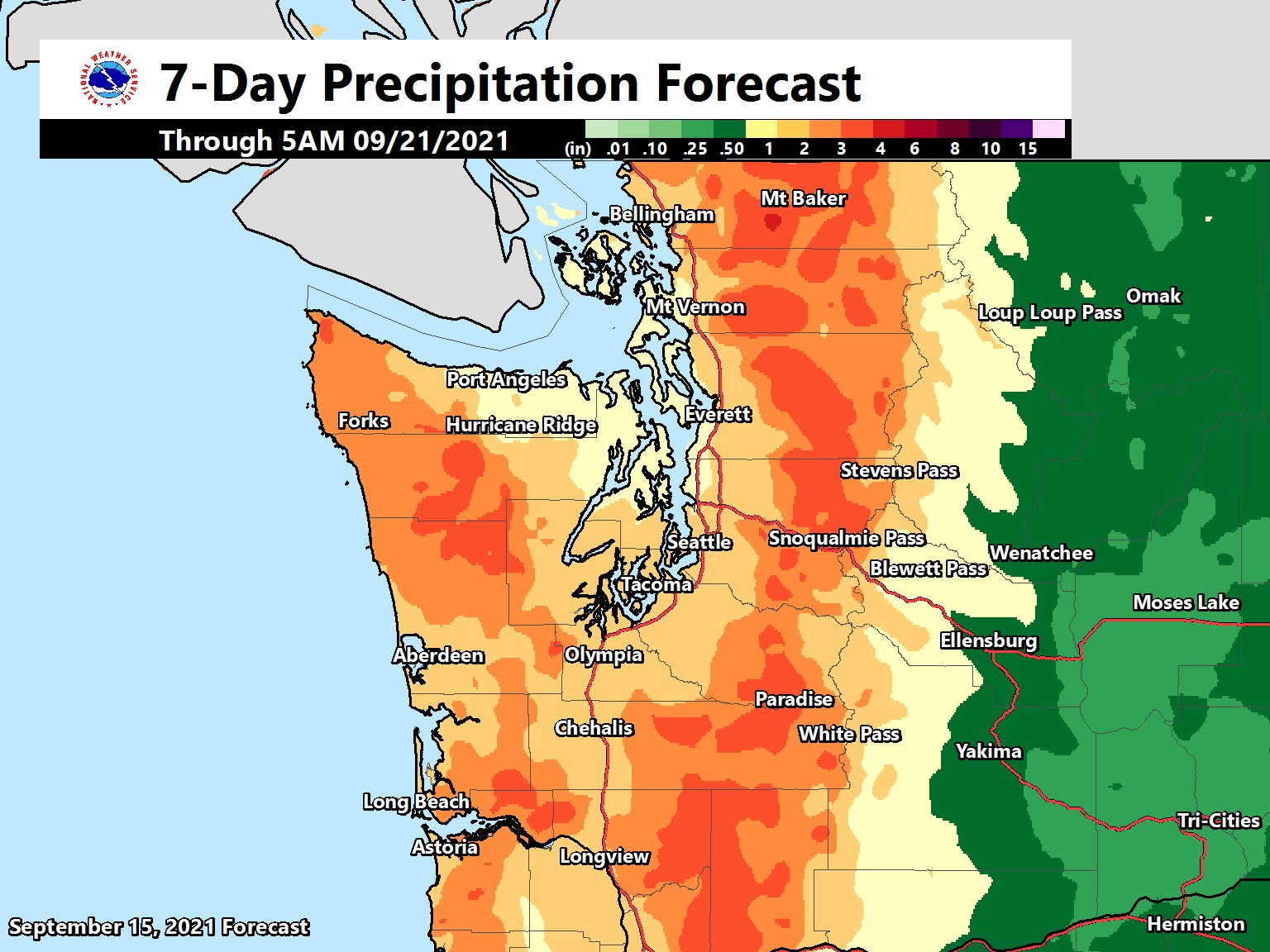
The north of Washington State is under flood watch again. Mesoscale systems are intermediate in scale (areas up to several 100 miles/ km), smaller than synoptic scale systems but larger than microscale systems. Those time references are Zulu Time. 21Z = 1 pm Pacific Standard Time (PST); 06Z = 10 pm PST. Would it not be simpler if the entire world switched to Zulu Time? Zulu Time was called Greenwich Mean Time (GMT) before 1972: the time at the zero meridian in Greenwich, London. Today it is also called Coordinated Universal Time or Universal Time Coordinated (UTC). [Graphic from NOAA Weather Prediction Center]
The heavy rains of the last few days has stopped, but there is extensive flooding in Whatcom County (in the far northwest, against the Canadian border).
Interstate 5 is also closed overnight near Bellingham due to a mudslide.
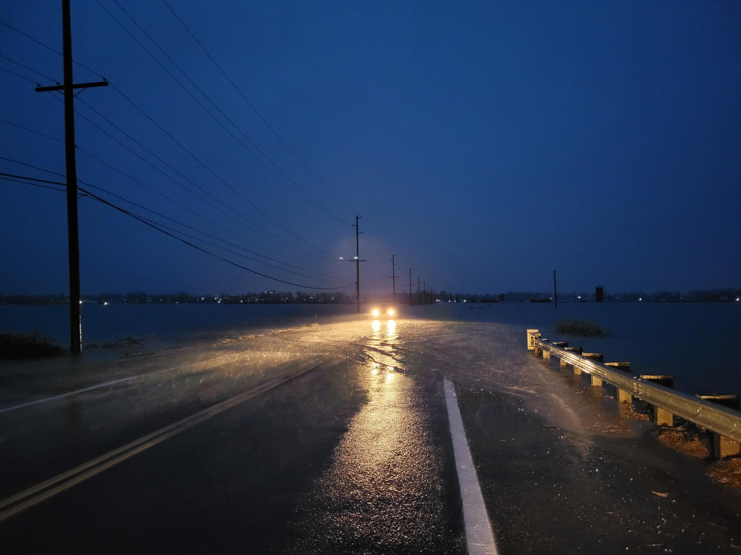
Untitled picture of Hannegan Road, between Bellingham and Lynden (posted on the website of KGMI News). Looking at Google maps, I believe that the water is from Tenmile Creek nearby, that is flooding.
P.S. I’m not sure where this motorist is coming from, but it’s very dangerous to drive into or through running water, and even more so in the dark.
It has been a soggy week.
The rain gauge at Sea-Tac airport has already logged more than 5 inches of rain for the month of November.
There is a 12-hour break in the rain right now, but more on the way for Saturday, Sunday and Monday.
Most of the rivers here are under a flood watch until Tuesday afternoon.
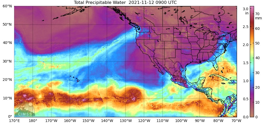
A plot of precipitable water* from overnight. (It’s a classic ‘Pineapple Express’: moisture builds up in the tropical Pacific around Hawaii (on the left, middle of the picture), and then stream towards, and wallop the Pacific Northwest). *Precipitable water is the depth of water in a column of the atmosphere, available for precipitation. Tropical air masses hold a lot of PW. [Text and graph posted by National Weather Service Seattle @NWSSeattle on Twitter]
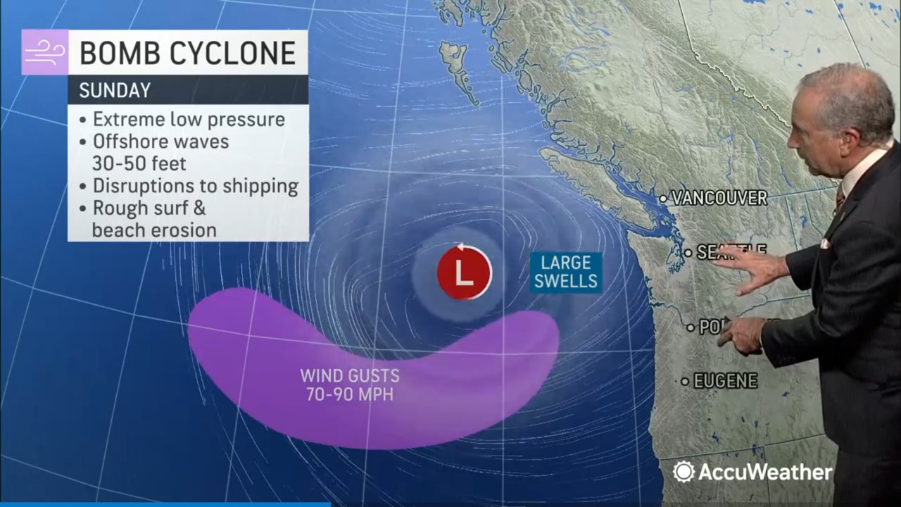
A very large ‘bomb cyclone’ storm system in the northeast Pacific Ocean generated an atmospheric river of rain that hit northern California today. Most of the West Coast had storm winds and rain as well.
There are reports of flooding and mudslides from California, but the good news is that the storm has brought the 2021 wildfire season to an end.
The bomb cyclone: a powerful, rapidly intensifying storm associated with a sudden and significant drop in atmospheric pressure, that occurred over the northeast Pacific on Sunday. We had blustery conditions and rain here in the city in Seattle, but not nearly as much rain as northern California. With those 30-50 ft swells, I hope there were no containerships in the area. One near Vancouver Island had lost 40 containers overboard, a day or two ago, even before the storm was around. [Still from Accuweather video clip]We had reports of fallen trees and power outages on Sunday around the city, but late afternoon it was quiet and there was a nice sun-break. This is Republican and 16th Avenue at 4.18 pm as I went for a walk.
It was only 56 °F (13 °C) when I went out for a walk at 6 pm today.
Still not scarf & glove weather, though. I’d say those are for 45°F (7°C) and below.
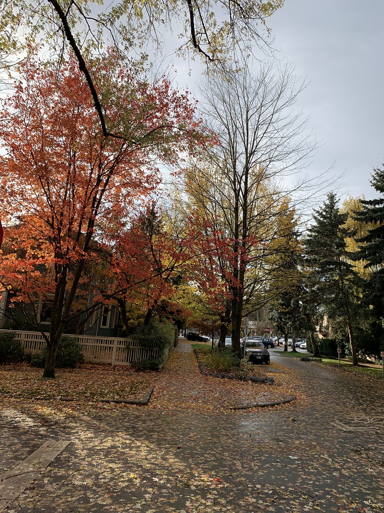
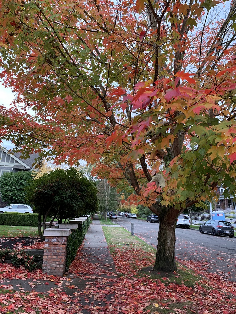
This is 17th Ave East here on Capitol Hill. The leaves are falling, the way they always do this time of year. When fall comes, the green chlorophyll of summer breaks down in leaves and its nutrients go back to the trunk and roots. These leaves turn yellow. The leaves on some trees turn red, and botanists are still not 100% sure why they turn red. The red color is due to a new pigment in the leaf called anthocyanin, which has to be made afresh as autumn takes hold. It may contain antioxidants to help against harsh winter conditions.
I realized on Sunday, driving around in the pouring rain, that’s it’s a new experience for me in my car (it’s been dry ever since I had gotten the car at the end of June).
The windshield wipers switch on automatically, but at times they seem to be a little too frantic (enthusiastic?) with the wiping. I intervene then, and adjust the wiper frequency down a notch.
I like the stalk on the right of the steering wheel to push on*, to get to the wiper controls (and not to have to go through the console screen selections).
*Tesla’s new steering wheel on the Model S and X has none of that, as the steering column is not equipped with any stalk.
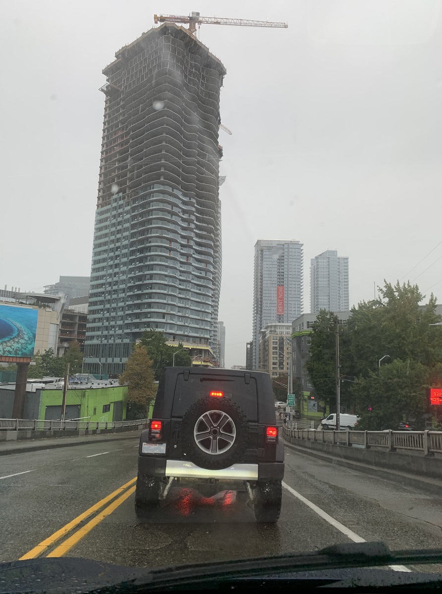
I am on Denny Way, waiting at the traffic light to turn left, to get to I-5 South. Looks like the 1200 Stewart St apartment tower has topped out (45 floors of apartments). The twin towers in the distance on the right, are part of the 1120 Denny Way apartments (construction is just about complete).
We have had about 1 in. of rain here in the city, and there will likely be more by the way of showers tomorrow.
The snowcap on Mount Rainier’s peak is back, after most of it had melted away in the heat of the summer.
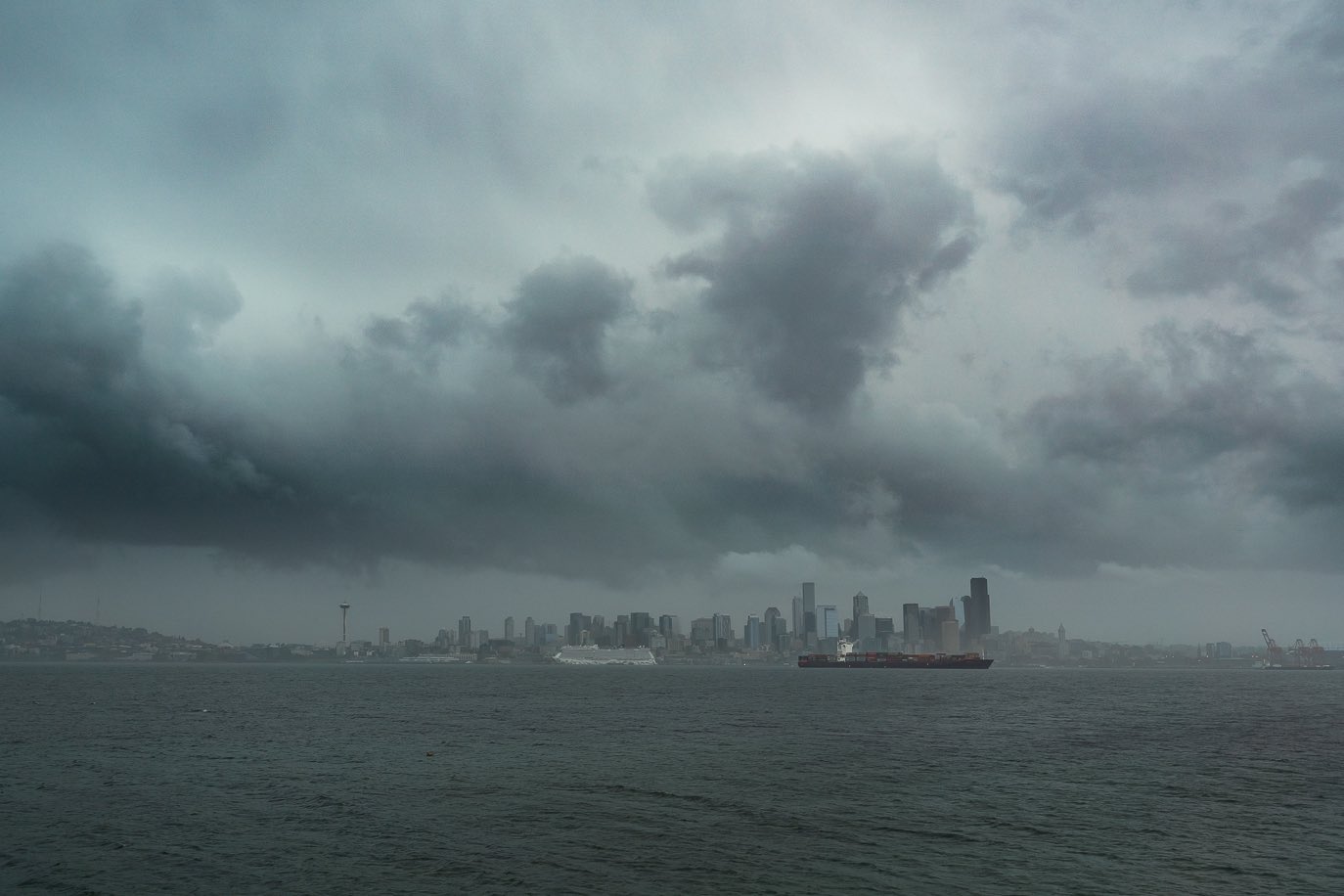
Stormy weather rolling in towards the city across Puget Sound this afternoon. Rain came down during Friday night, with a break on Saturday morning, and then more rain. [Picture posted by Kristy Sharkey @kristy_sharkey on Twitter]
The Puget Sound area had less than 0.1 in of rain the last 90 days.
Rain is finally on the way.
My lavender asters with their golden buttons are in full bloom here at the end of summer.The rain will start on Friday, and continue through the weekend (1-2 inches in the city). The mountains will get the most, and above 6,000 ft there will be snow.
There was a little rain on the ground this morning, and still enough to hear it patter down the gutter from the roof, as I opened my back door.
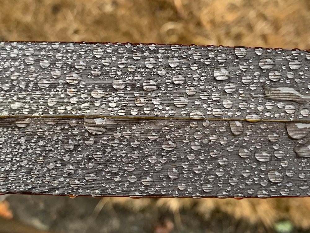
Sticky blobs of rainwater, magnifying the fine stripes on the dark burgundy leaves of my ‘Black Adder’ phormium flax plant. The dry lawn grass below should start to green up now that the rain is coming back.September should bring some 2 in. of rain.
On August 22, Tropical Depression Henri dumped 1.94 inches on Central Park between 10 p.m. and 11 p.m., breaking the record for the most rain in an hour in New York City. Ida bested that record just 11 days later, dropping three inches of rain between 8:51 and 9:51 p.m. on Wednesday night. The intense downpour caused flooding throughout the city, as well as the first flash-flood emergency* ever to be issued in New York City.
– Matt Stieb writing in Intelligencer
*Emergency means the flooding poses an imminent, ongoing severe threat to life, and catastrophic damage.
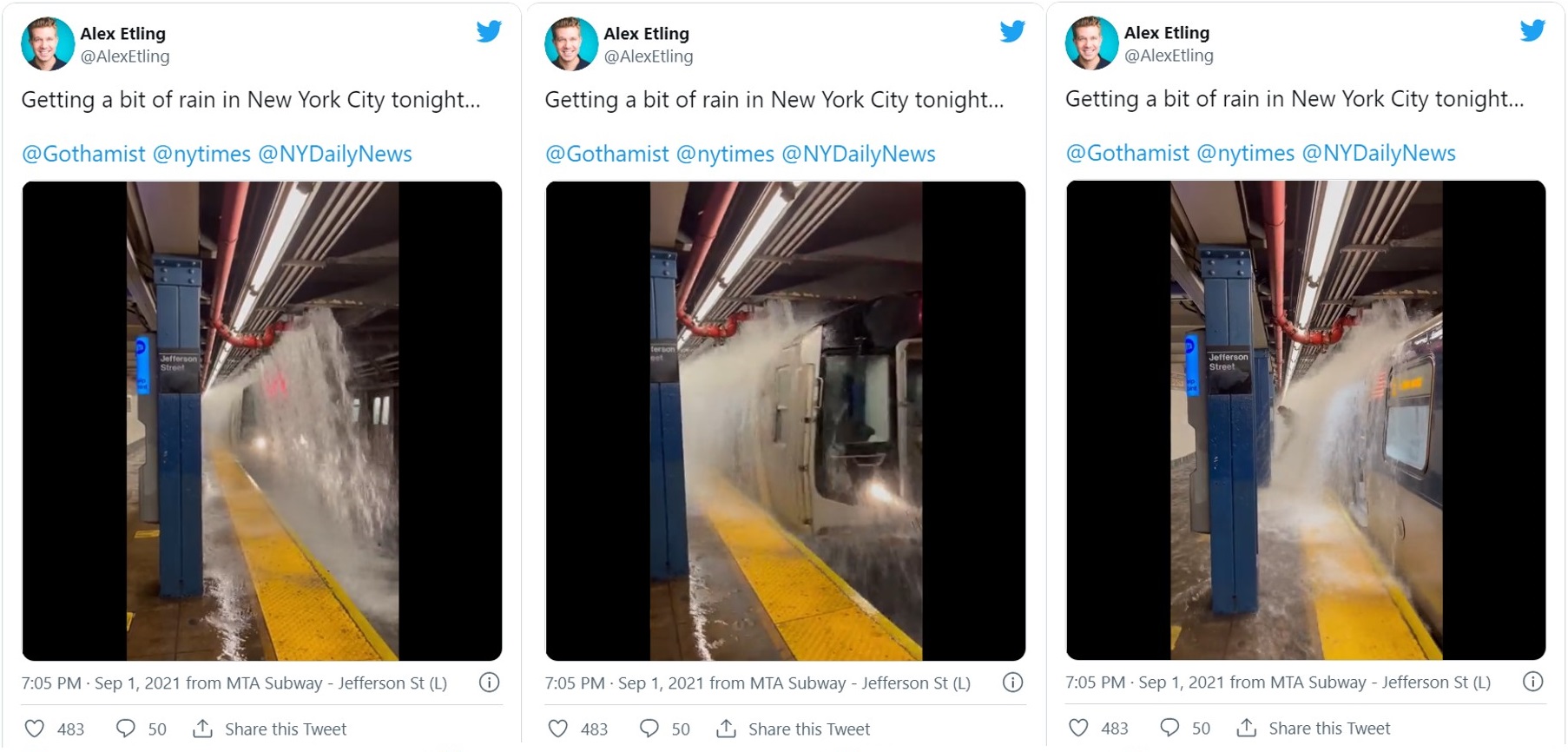
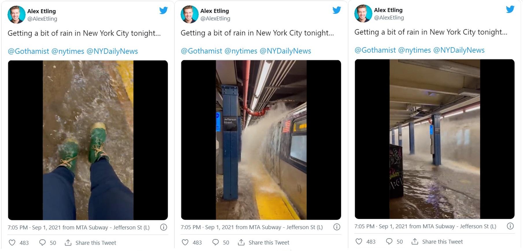
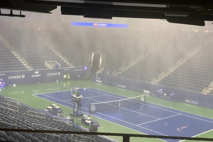
Scenes from a disaster movie (only, it’s real) in the subway stations (before service on the subway system was completely suspended). The L Train coming into the Jefferson Street station in Bushwick (Brooklyn) with water just cascading onto the rails. Train stops. Passenger jumps out onto the platform, getting completely drenched (far right). [Stills from a video clip posted by Alex Etling @AlexEtling on Twitter]The platform is flooded. The doors close. The train departs. [Stills from a video clip posted by Alex Etling @AlexEtling on Twitter]The empty Louis Armstrong Stadium in Queens, New York City is soaked and the court is under water. No tennis at the US Open tonight. [Photo: dpa/picture alliance via Getty Images]
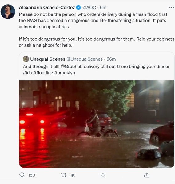
This is in Brooklyn, as well. That looks like at least 12 inches of water on the street surface. Congresswoman Alexandria Ocasio-Cortez chiding people that order food delivery during a flash flood emergency. (Grubhub is at fault as well. Hopefully the delivery person will be given an appropriately generous tip).
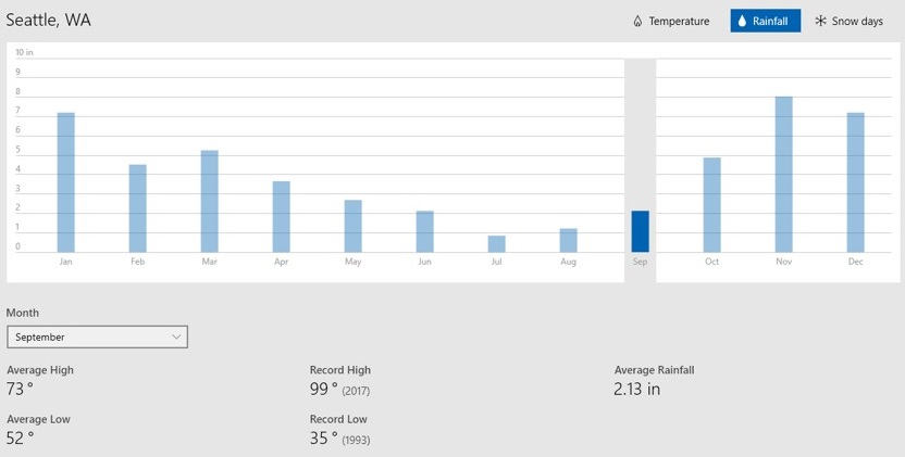
The gauge at Seattle-Tacoma airport recorded only 0.11 inches of precipitation for the month of August, far below the mean of 0.92 in.
The East Coast of America is getting soaked, and the West is dry as a bone.
There were a few drops of rain today— just a few drops. So I went out and watered the shrubs and flowerbeds at the front of my house. (I don’t water the lawn. It will green up again when the rain starts). ‘I like your new ride’ said my neighbor, when he saw me. ‘Oh yes, I love it’, I said, thinking he referred to my new car. ‘No, no, this one’, he said, pointing to the LINK scooter that someone had left in front of my house. ‘Oh THAT – I’m not touching the scooter’, I said. ‘Riding it can only be trouble’.
Hurricane Ida is the ninth named storm of the 2021 Atlantic hurricane season, and formed on Thursday in the Caribbean Sea.
A levee failed near Highway 23, resulting in flash flooding. I hope Monday will bring news that the infrastructure that had been added after hurricane Katrina, to mitigate the storm surge threat from the ocean and the bodies of water in the area, had done exactly that.
Mon 8/30 update: Reported by Reuters: A $14.5 billion system of levees, flood gates and pumps has largely worked as designed during Hurricane Ida, sparing New Orleans from the catastrophic flooding that devastated the area 16 years ago in the wake of Katrina, officials said.
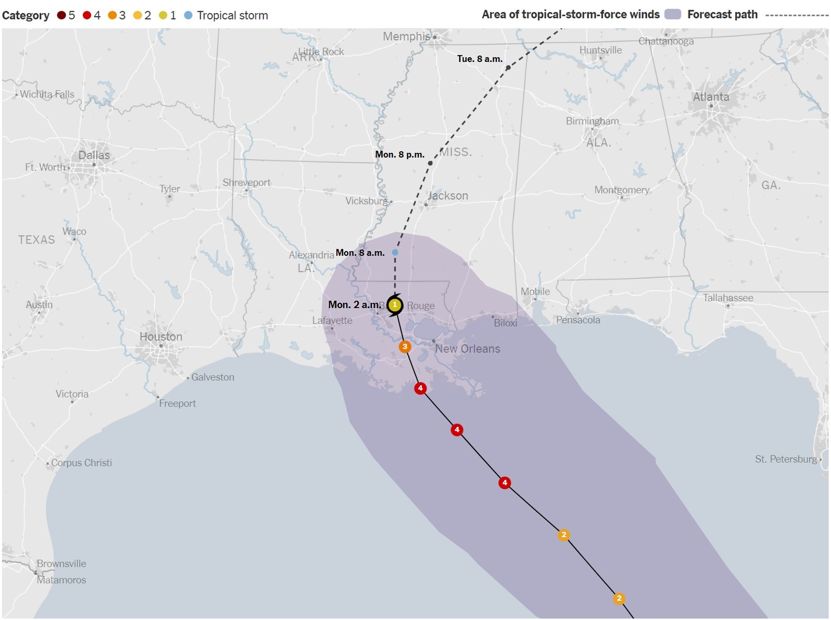
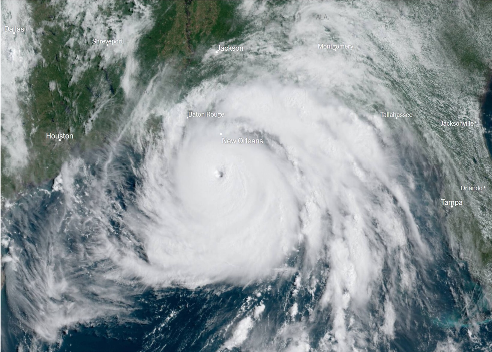
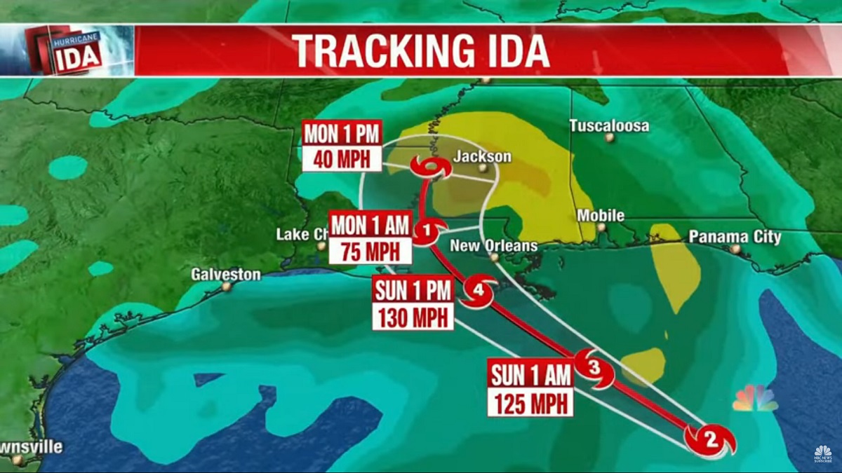
Here’s the projected path of Hurricane Ida. It dumped some 10 inches of rain on the Louisiana coast, and will soak Mississippi with rain on Monday. [Map by New York Times online].A satellite image of the storm on Sunday morning. It’s a massive, massive system, more than 500 miles across. [Posted by the New York Times online/ taken by the National Oceanic and Atmospheric Administration].
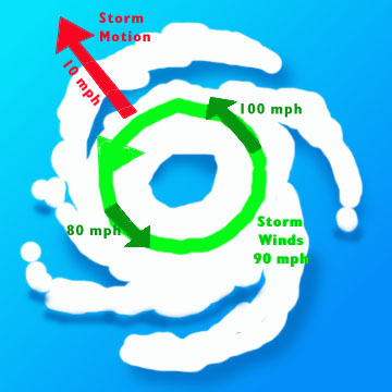
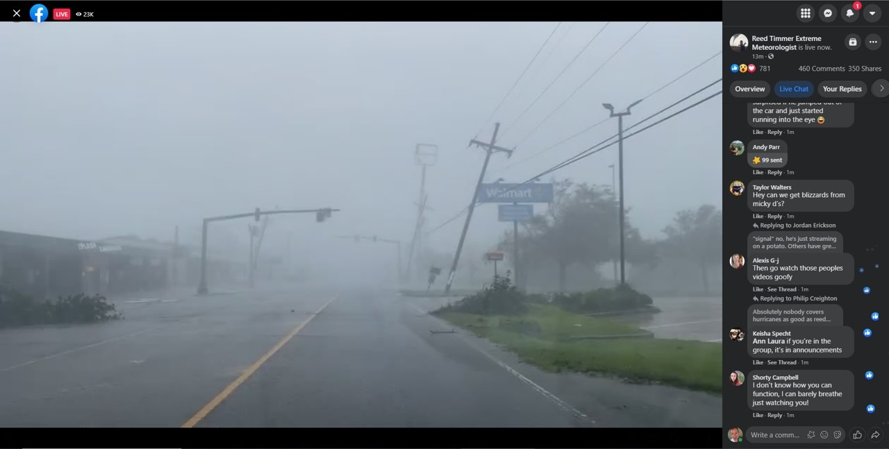
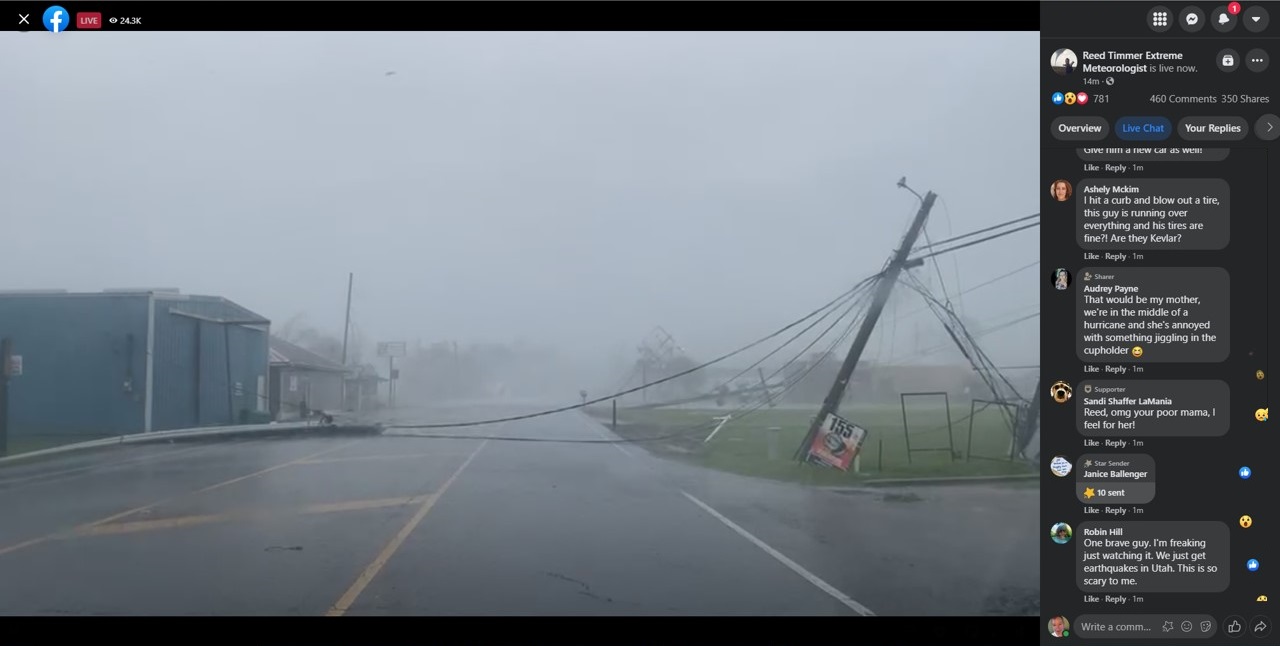
In the Northern Hemisphere, the winds in a hurricane go counterclockwise. The strongest winds are almost always found in the eyewall, at or near the right front— the forward—quadrant of the storm. The forward speed of the hurricane is added to the rotational wind speeds generated by the storm itself. [Graphic from Wikipedia].This is at the Walmart at Raceland, Louisiana, just off Route LA-1. I am guessing the wind speed is at least 80 mph here; Reed Timmer kept saying he is in the eyewall of the storm (it’s several miles wide), and trying to get to the eye of the storm. [Still from Facebook Live feed from Reed Timmer Extreme Meteorologist].
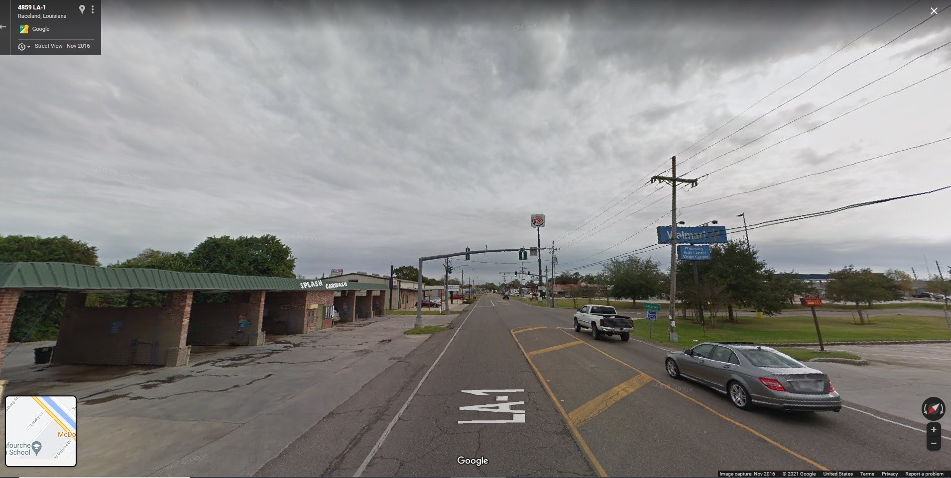
Here’s a Google Streetview shot of the same location in Raceland, LA. There’s a Splash Carwash on the left (will not need THAT today!), with the Walmart on the right.
Downed powerlines blocking the road just a little further up in the road on LA-1 by Raceland, LA. (Stating the obvious: always stay well clear of powerlines!). Storm chaser Reed Timmer found a way around these, using the surrounding streets. [Still from Facebook Live feed from Reed Timmer Extreme Meteorologist].Ida made landfall as a Category 4 hurricane near Port Fourchon, Louisiana. The entire city of New Orleans was without power on Sunday night.
I watched a little bit of storm-chasing on YouTube and Facebook Live today.
Below are stills from the Facebook Live feed from Reed Timmer ‘Extreme Meteorologist’.
With Hurricane Ida projected to slam Louisiana on anniversary of Katrina, anxiety grips the region
People across Louisiana were deciding Saturday whether to leave or ride out what officials were calling a potentially “life-altering” storm as Hurricane Ida rapidly gained strength in the warm waters of the Gulf of Mexico — threatening to become one of the strongest storms to make landfall in the state since 2005, when Hurricanes Katrina and Rita devastated the region.
The National Hurricane Center was predicting that Ida would strengthen to a Category 4 hurricane with 140 mph sustained winds before making landfall in rural Terrebonne Parish, southwest of New Orleans, on Sunday afternoon. The storm was projected to bring an “extremely life-threatening” storm surge, “potentially catastrophic wind damage,” and widespread flooding, and with Ida projected to come ashore on the 16th anniversary of Hurricane Katrina, anxiety gripped the region.
– Emmanuel Felton, Tim Craig, Carmen K. Sisson, April Capochino Myers, Leslie Fain & Ashley Cusick writing for the Washington Post
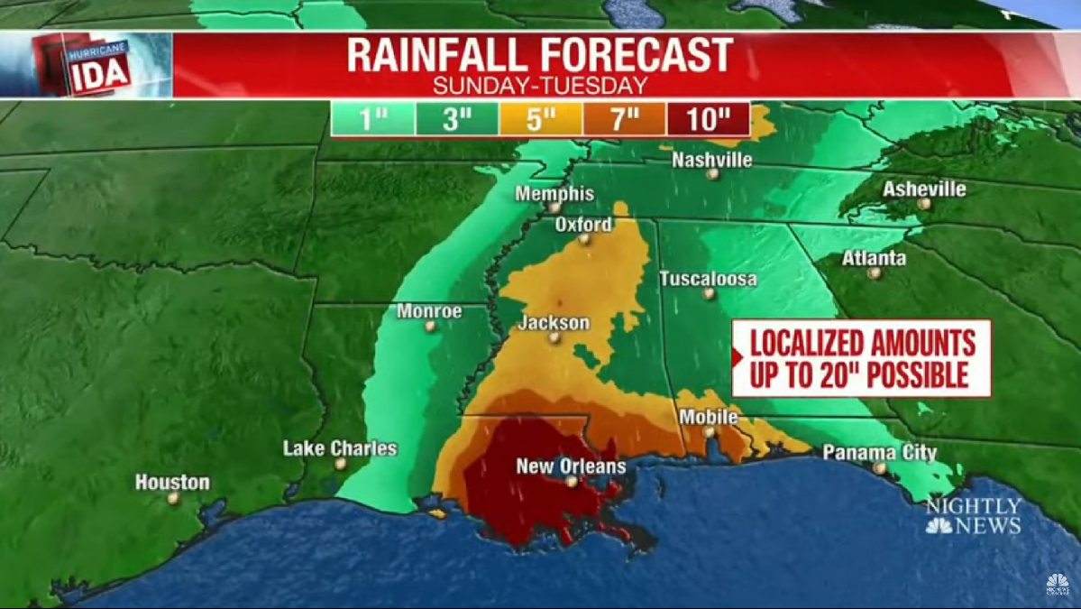
The eye of the storm was in the Gulf of Mexico on Saturday night. New Orleans and Baton Rouge in Louisiana are all but assured of hurricane force winds (potentially >110 mph) and a storm surge of up to 15 ft. [Graphic from NBC Nightly News]Rainfall exceeding 10 inches is expected around New Orleans. [Graphic from NBC Nightly News]
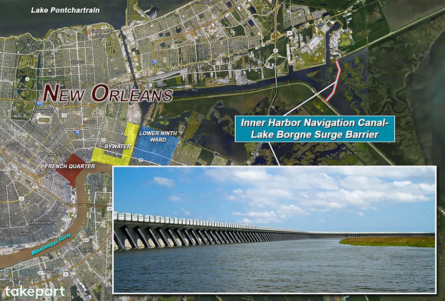
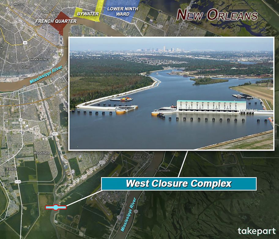
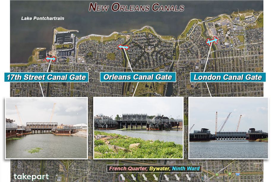
Batten down the hatches, close the gates
Today, a decade* after Katrina left 80 percent of New Orleans underwater and killed more than 1,600 people, the Big Easy has been reconstructed as a walled city. The Lake Borgne Surge Barrier is just one of a series of gargantuan structures and reinforced levees and floodwalls designed to defend the city against a 100-year storm—a Katrina-like catastrophe that has a 1 percent chance of occurring in any given year. This feat of engineering, prosaically called the Hurricane and Storm Damage Risk Reduction System, forms a 133-mile enclosure around New Orleans and the 350 miles of canals that traverse the city—the canals the Corps had relied on to contain floods and that failed so disastrously in 2005. “We’re taking the fight to the storm instead of letting it come to us,” says Boyett.
-*From a 2015 article asking ‘Will the ‘Great Wall’ of New Orleans Save It From the Next Killer Hurricane?’ by Todd Woody
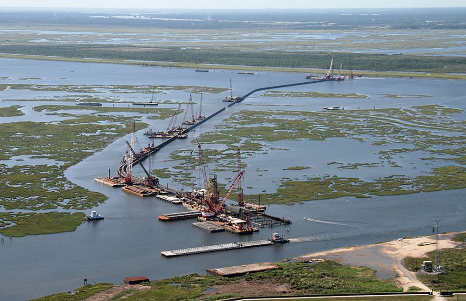
Inner Harbor Navigation Canal–Lake Borgne Surge Barrier. (Map: Google Maps; photo: ASCE/Facebook; infographic: Marc Fusco)Inner Harbor Navigation Canal–Lake Borgne Surge Barrier under construction in 2010. (Photo: Wikipedia)(Map: Google Maps; photo: Courtesy U.S. Army Corps of Engineers; infographic: Marc Fusco)(Map: Google Maps; photos: Mary Grace McKernan; infographic: Marc Fusco)
The sky was still hazy today, but it will clear out tomorrow.
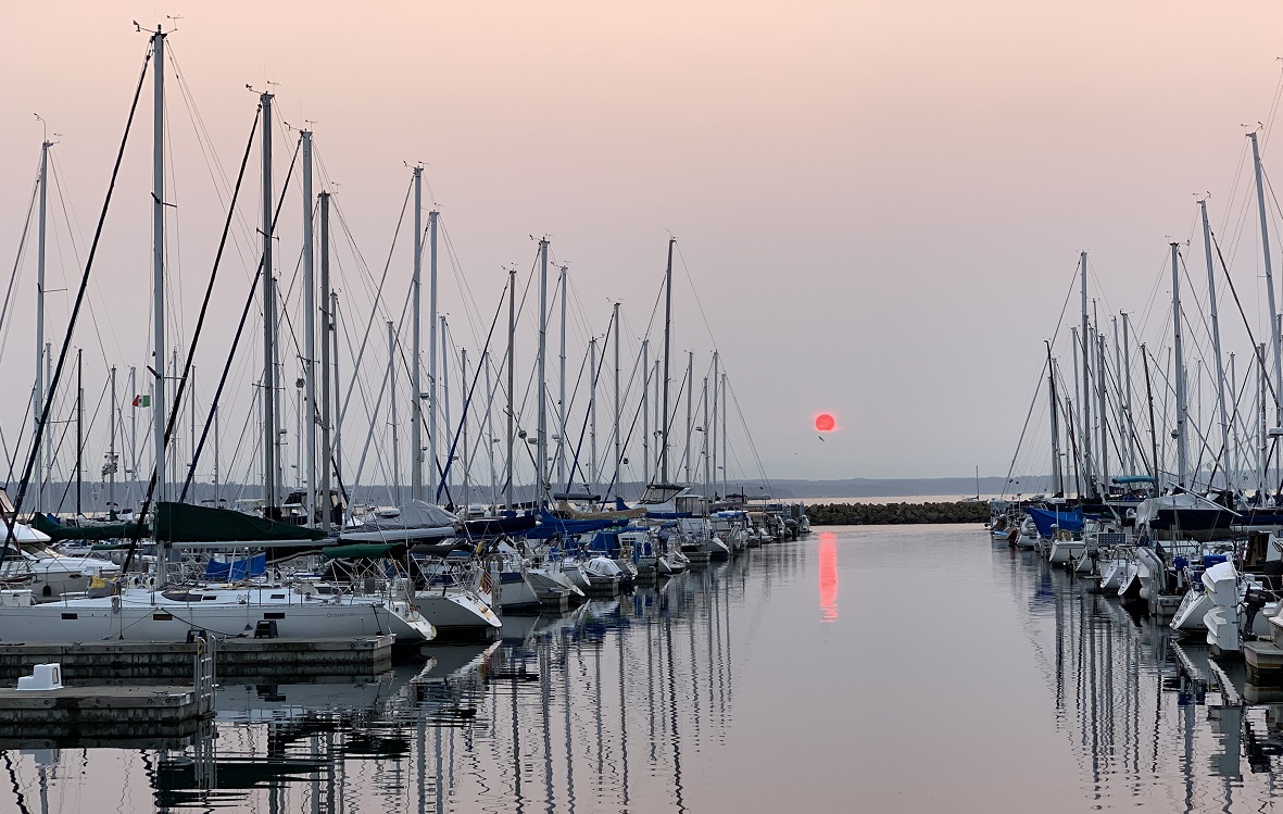
Bryan, Dale and I drove out to Shilshole Bay Marina after dinner, to catch the sun as it was setting.
It’s 8.05 pm and sunset today was officially at 8.22 pm. We are looking west, across Puget Sound and Bainbridge Island in the distance. Shilshole Bay Marina is in the foreground. Soon after I took this picture, the sun disappeared behind the (invisible) Olympic Mountains lying further to the west of Puget Sound. [Photo taken with iPhone Xs]
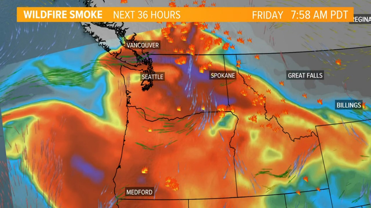
The high was 94°F (34°C) here in the city today, and the air quality was not the best (wildfire smoke from Canada and eastern Washington). Bellingham to the north of Seattle recorded 100°F (38°C), a new record for any month.
Even so, early evening found me on the Lower Woodland Park tennis courts for the regular Thursday night social tennis. I made sure I had extra water and a banana to keep me going.
Update Fri 8/13: Friday’s highs here in Seattle reached 96°F (35.5°C). It is going cool down on Saturday and Sunday, thankfully.
I’m keeping my windows and doors closed on Friday and Saturday. This simulation has lots of red, the dark red and purple (the worst air quality). Vast volumes of smoky air are swirling around, from the fires in Canada, in eastern Washington, in Oregon and down in California. We need rain, but it’s several more weeks before the rainy season starts.
A little rain fell into the gauge at Seattle-Tacoma airport yesterday, ending the 51-day dry streak there.
There were pleasant, cool temperatures around the city today (69 °F/ 21 °C). A little bit of rain may fall later tonight and in the morning.
Summer is definitely not over, though: we are going to get into the mid-90s by Thursday, and even have to deal with wildfire smoke.
Killer cartoon by Lebanese-Swiss cartoonist Patrick Chappatte, from Der Spiegel. ‘Warming, Floods, Fires. No U-turn possible’. Yes, there is no turning back to a totally clean start, but we can still mitigate and reduce the changes we are making to the climate with our actions. That family car has no tail pipe, so I trust that means it is an electric vehicle!
A few rain drops fell on the tennis courts at Woodland Park tonight, and there was thunder and lightning overhead.
There was a little bit of rain in the city as well, but none was recorded at Seattle-Tacoma airport. Today was day 50 without rain there (longest on record is 55, in 2017).
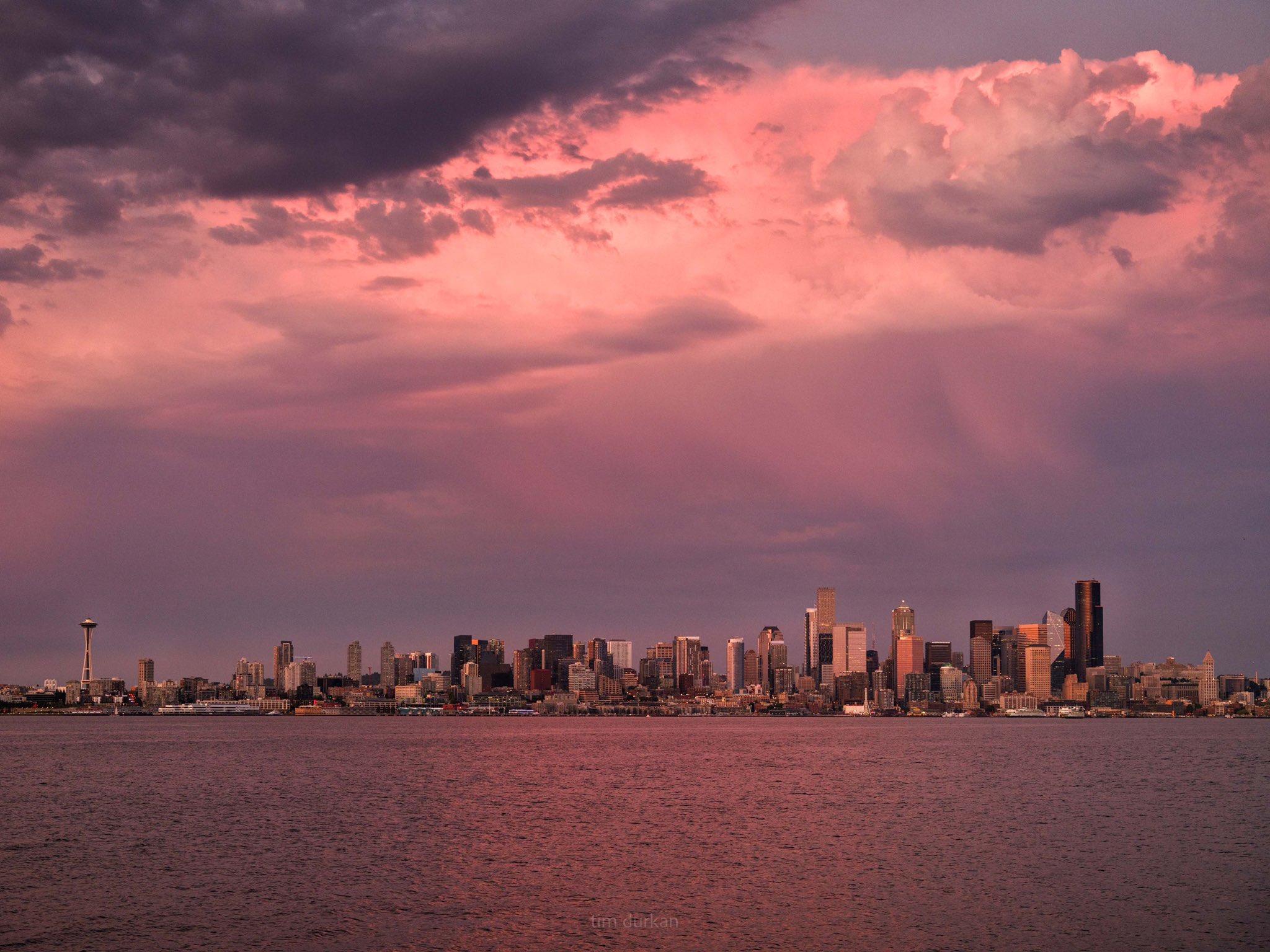
Gorgeous pinks and grays, in this twilight picture by Seattle photographer Tim Durkan @timdurkan on Twitter.
It’s official: the rainfall for July was a T (for trace), as measured at Seattle-Tacoma airport. The weather people are promising us that it will rain on Friday, though.
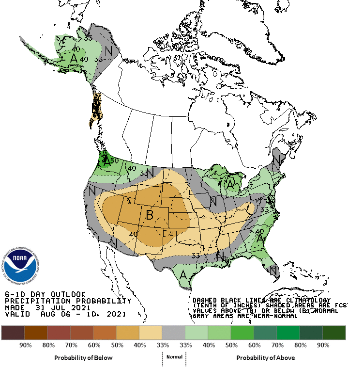
Mirror, mirror, on the wall .. who is the greenest of them all? Washington State, of course. (More than a 50% ‘precipitation probability’— I think that means ‘chance of rain’— for Friday & the following 5 days, says NOAA). [Graphic by NOAA/ National Weather Service]
As the dry days of July come to an end, we are having warmer weather through Saturday.
The highs are around 89 °F (32 °C).
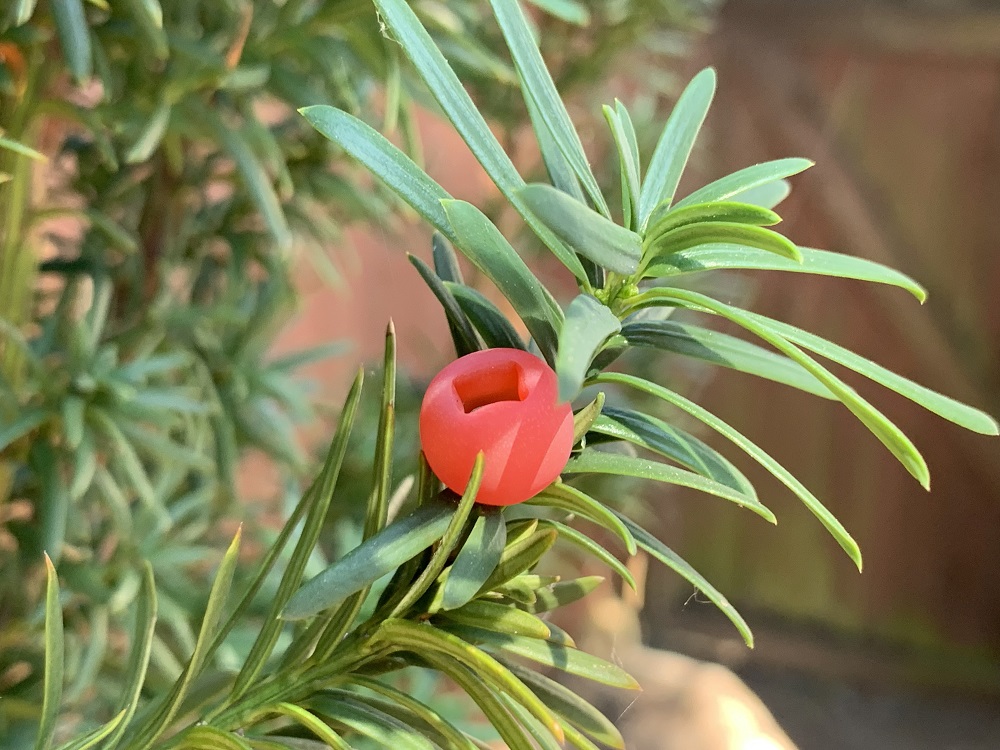
The hybrid yew tree (Taxus x media ‘Maureen’) at the back of my house is producing a few round red berries with square-ish openings. The leaves look like needles from a distance, but a closer inspection reveals they are just long and narrow leaves.