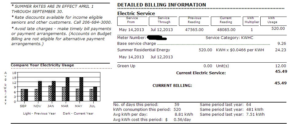
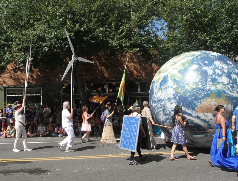
Thursday/ Skagit River Bridge update

It’s been a week since the collapse of the Skagit River Bridge on Interstate 5 north of Seattle.  Washington State Department of Transport (we just call them ‘wash-dot’ here on the news) has dredged up the bridge section and vehicles from the river, and is getting ready to put a temporary section in place.  I see Wash-DOT splashed out on Yahoo’s photo site (called Flickr) with detailed pictures.  Here is the link http://www.flickr.com/photos/wsdot/sets/72157633665218854/

Skagit River Bridge WSDOT

Tuesday/ it’s summer (unofficially)

Here’s a nice view from behind the overhand of a maple tree onto the pavement on 15th Ave, seen as I went for a little walk late Tue afternoon.  The leaves make a nice camouflage pattern (the French word derived from camoufler, to disguise).  After Memorial Day it’s ‘unofficially summer’ but the warm and dry weather still has to arrive here in Rain City.

IMG_6835

Sunday/ trip to Westport

On Sunday Bryan, Gary and I made a mini-road trip out to Bryan’s family in Westport.  Westport is a seaside town on the west side of the Olympic Peninsula.  It’s about 2 hours one way.

Seattle to Westport
It’s not a straight shot out to Westport since the Puget Sound is ‘in the way’. We went south on I-5, and then used an assortment of State Routes to get to Aberdeen and then to Westport.
IMG_8621 sm2
Here’s the Nisqually River bridge on our way south on I-5, a ‘polygonal Warren through truss’ bridge that was constructed in 1967.
IMG_8629 sm2
This is a draw bridge over the Wishkah river in the city (town) of Aberdeen. This bridge was constructed in 1924.   The town of Forks is further north on the Olympic Peninsula, now a tourist destination for ‘Twilight’ fans (a TV and movie series about teenage vampires, with the town of Forks as its setting).


IMG_8637 sm2
And is this a light house? Nooo .. it is the Westport Winery, in fact. We made a stop here to pick up a carrot cake for a dessert to the lunch we were planning, at the bakery inside.
IMG_8650 sm2
We’re done with lunch, and here is what the Westport beach looks like.  It was great to walk on the sand and smell the sea ..
IMG_8648 sm2
.. and check out the sand dollars that are plentiful!  I picked up these five on the beach in no time. They don’t have the ‘key hole’ slots of the ones we have in South Africa, but the five leaved ‘flower’ pattern is the same. They are called ‘pansy shells’ there, after the flower with the same name.  (It’s not really a shell, since its the skeleton of a flat urchin. In the live urchin there is a velvet-like covering of fine bristles on the skeleton).
IMG_8660 sm2
And here is a real lighthouse : the Grays Harbor Lighthouse close to the beach that we walked on.  It was built in 1898 and is adjacent to the Westport Light State Park on Coast Guard property.

Saturday/ the Seattle Central Library

It’s been many years since I had been inside the Seattle Central Library on 4th Avenue, and today I went there, also in search of a 1967 Time-Life Sciences book.  (The book is long out of print and has pictures of an Einsteinian ‘relativistic’ train robbery in that I am very fond of.)   Alas, I did not find the book, but I took some pictures.  The library opened in 2004 to mixed reviews, some criticizing it for being relatively isolated from 4th Ave and 5th Ave and not easy to get into and out of .. but its current usage is actually double of what was estimated when it opened.   

IMG_6764 sm
The side view of the library (the back) on 5th Ave in Seattle’s downtown.
IMG_6779 sm
This is the 7th floor where I was hoping to find my book.   This book of city scapes was on display and had a nice picture in of Cape Town, South Africa. 
IMG_6782 sm
Here I am making my way up with the neon yellow-green escalator up to the 10th floor.
IMG_6786 sm
Some library souvenirs for you? The studious rubber duckies are cute.
IMG_6795 sm
This video art work is on the escalator between the 3rd and 5th floors. It’s a little creepy – but then I suppose that’s what the artist wanted it to be?
IMG_6793 sm
Here is the view from the 5th floor down to the ‘commons area’ on the 3rd floor.

Thursday/ yikes! the bridge is out

From Kiro7tv.com : The Interstate 5 bridge over the Skagit River at Mount Vernon collapsed Thursday evening, dumping vehicles and people into the water shortly after 7 p.m.  Here is a link http://www.kirotv.com/gallery/news/i-5-skagit-river-bridge-collapses/g9w8/#last.

Three people and their cars ended up in the river, but was pulled out and seem to be doing fine.  At this point there are no known fatalities. The bridge was built in 1955*, and is some 65 miles north of Seattle, and the four-lane structure sees an average daily traffic of about 71,000.  So this spells trouble for the immediate area. There is an alternate route and a newer bridge, but it was not designed for nearly as much traffic.

*Designated ‘functionally obsolete’ on its most recent inspection reports but apparently that does not mean the bridge is unsafe.  (Sounds as it was overdue for an upgrade or replacement, though).

c7bridg2
Here is an aerial view of the Skagit River bridge on I-5 some 65 miles north of Seattle that collapsed Thu night after a too-tall truck struck the overhead trusses.
IMG_6738 sm
Here is my first official Tesla sighting in Seattle, today Thursday. I was across the street and the white Tesla (brake lights on, middle of the picture) came right by -stealthily as these electric cars do – and turned into the Starbucks on Olive Way to pick up a woman with a latte (I’m guessing) in hand. I want one! (A Tesla).
IMG_6734 sm
My friends and I like to go to alehouses, and here is Wednesday night’s pick : the Tippe and Drague Alehouse in Beacon Hill. I had a Gigantic Vienna Lager. (Regular size, the gigantic is part of the name of the beer).

Tuesday/ not a trick question

IMG_6724 sm
What is the longest floating bridge in the world? asks the metal tile.
SR520 Floating Bridge
The State Route 520 floating bridge is more than 7,580 feet long and has been in operation around since 1963. Currently a newer, bigger bridge is under construction for a whopping $4.65 billion, scheduled to open in 2015.

This metal tile that I found under my feet while  I was at the Westlake Center plaza in downtown Seattle, poses a question.  It is one that a Seattle resident should be able to answer (or at least guess) easily : What is the longest floating bridge in the world? (Side comment .. shouldn’t the question have said ‘WHERE is the longest floating bridge in the world?). Answer : In Seattle, of course. Well, between Seattle and Redmond. So that the Microsofties can get across Lake Washington.  Here is a post I made long ago  SR 520 showing what a cross-section of the bridge will look like once the renovations and expansion to it is complete, scheduled for 2015.

Sunday/ Denny Substation and its utilidor

I learned a new word while listening to a discussion of the Denny Substation’s progress on the city council’s web site : there will be a utilidor for the station.   Utilidor is short for utility corridor (really just a utility tunnel, to carry cabling and to house equipment underground).  There’s not much to see behind the Denny Substation Project site yet .. right now they are scooping up the top two to four feet of soil to clean up oil and grime from the old Greyhound bus station maintenance facility.   It’s still a ways to 2016 when the substation will be complete.

IMG_6689 sm
The sign on the fence at the Denny Substation Project site. I like the symbols for the substation and transmission (at the bottom).  Transmission lines are the high-voltage lines from the power plant to the substation.  But the lightning bolt for ‘Distribution’ from substation to homes is a little off .. it should have been one of those wooden poles with a cluster of drum-shaped transformers, not?

Friday/ Olive 8 is back

The picture is from Thursday.  I am standing on the corner of 7th Ave and Olive Way. I had just left the Vessel bar/ watering hole where I had a beer with a few colleagues after work.  The ‘Olive 8’ condo tower still has 5 units left, but it seems like the opportunity to snap up a condo on the cheap from the distressed developer has now come and gone. The building was completed in 2009, and one bedroom condos typically listed for $500,000.  One condo for sale on the property website Zillow had been sold in Nov 2010 for $328,000, probably by the developer to a speculator.   The listing price (it’s a one bed, one bath condo) is now back up to $495,000.

IMG_6687 sm
On the left is the still-new Olive 8 condo building on Olive Way and 8th Ave in downtown Seattle, outlined against the afternoon’s clear sky.

Saturday/ the Elysian Superfuzz Pale Ale

It looks as if two weeks of dry weather is coming to an end today, and we had beers on Bryan and Gary’s deck tonight to enjoy the last of it.  Check out Bryan’s ‘Elysian Superfuzz Pale Ale’ beer, brewed with blood orange to give it a citrussy taste.  I buy the little blood oranges here at the grocery store when I see them.  They are small and sweet and make you feel like a vampire when you bite into the juicy dark red fruit.  Njarr !

Superfuzz Pale Ale
The Elysian microbrewery’s Superfuzz Pale Ale is brewed with blood oranges ..
IMG_5496 sm
.. like these. It really does look as if there is blood in the orange!


Monday/ 87 ºF a record high

Monday Record 87 sm
Temperatures reported by Kin5 TV on Monday. Monday’s high was 87 ºF (30.6 ºC) and the previous record high from 1957 is 79 ºF (26.1 ºC).


I thought it was warm on Monday – but didn’t realize until the evening news that the 87 ºF (30.6 ºC) we had in the city was quite an aberration.  It was the highest May 6 temperature on record, and by a wide margin.

Sunday/ Madison ‘Beach’

So .. does a beach have to have sand?  Madison Beach here alongside Lake Washington does not really have sand, and the water is not salty. We have to make do with what we have since it’s a heck of a drive out to the open ocean’s beaches here from the city !

IMG_6608 sm
The scene at Madison Beach park at 5 pm on Sunday afternoon.   The water is still cold, so only the bravest souls venture in this early in the season. 
2008-0249
It is 2.2 miles from where I live (A) to Madison ‘beach’ on Lake Washington (B).  I walked out there; it’s downhill most of the way.  And then I cheated and caught the No 11 bus to bring me back three-quarters of the way.

Friday/ blue sky

We have a high-pressure cell hovering over us this weekend – keeping the clouds of the jet-stream away, and giving us a beautiful clear blue sky* and warmer temperatures (70’s º F/ 20’s ºC).

*And just why is the sky blue? Because of Rayleigh scattering.  In plain English, the molecules of the earth’s atmosphere scatter the shorter wavelengths of light from the sun more than the longer ones, and the human eye sees the blue.  If our eyes were more sensitive to violet light, the sky would have been violet.  When the sun sets, the scattering of the red color wavelengths become more predominant, and we see red and pink).

IMG_6577 sm
The Seaboard building with Friday’s blue sky behind it. Constructed in 1910 as offices, the upper floors have now been turned into condominiums for people that like to live right in the city.
2008-0167
Here’s a Google street view photo (same building on the left). After work I walked up Pike St (center of the picture) to catch one of the buses on the right that stopped by the white arches of the Convention Center in the distance, to take me to my home on Capitol Hill.

Wednesday/ Mayday mayhem

IMG_6566 sm
This sticker on the back of a parking sign here on 15th Ave in Seattle promotes the anarchists’ point of view (the faq stands for Frequently Asked Questions).

With Wednesday being May 1, there were street marches for workers’ rights and immigration reform here in Seattle.  Everything went OK but after 6 pm things turned ugly in downtown Seattle. Most of the marchers had dispersed by then, but a small group of self-described ‘anarchists’ started confronting the police, and damaged cars and windows by throwing rocks.  So some 17 people were arrested, and 8 police officers hurt – but mostly bumps and bruises.   My take? Hey, you’re not going to get an argument from me that we’re doing just fine with capitalism in the USA.  Capitalism is killing our morals and our future, argues Paul Farrell on the Wall Street Journal’s website Marketwatch : http://www.marketwatch.com/story/capitalism-is-killing-our-morals-our-future-2013-04-27?link=kiosk.  We cannot put everything up for sale. The examples he mentions : “for-profit schools, hospitals, prisons/ outsourcing war to private contractors/ police forces by private guards, almost twice the number of public police officers/ drug companies’ aggressive marketing of prescription drugs directly to consumers, a practice prohibited in most other countries.”   But to think we can live in a society with almost no government, no laws and no police (libertarian socialism, which seems to me pretty close to what anarchists stand for) – that is just a pipe-dream.

Sunday/ King Street Station is new again

I had time on Sunday to swing by King Street station just south of downtown Seattle.  The station was originally constructed in 1906 but recently renovated inside and out.  Wikipedia says it has Italianate architecture and Beaux-Arts architecture (OK! so now I know what that looks like as well).  The station is a stop on the Amtrak Cascades route that runs along the Cascade Mountains on its east, up from Eugene, Oregon to Vancouver in Canada.

Amtrak Cascades
Amtrak’s Cascades route is named for the mountain range on its east (when the train runs northbound).
IMG_1_8606 sm
King Street Station with the Amtrak track that brings the trains to it. Downtown Seattle is in the background.
IMG_2_8607 sm
A closer look. I love the copper trim on the awning.
IMG_3_8590 sm
This ceiling is upstairs, when one has entered through the main doors on Jackson street.
IMG_4_8591 sm
The main waiting room. The Amtrak train has actually just arrived from the south. It stops only for a few minutes, so I was too late to run outside and catch a better glimpse of it!
IMG_41_8593 sm
A beautiful inside corner with doors going to the streets and taxi stand.
IMG_42_8594 sm
A close look at the lamp fixtures and little mosaic tile trim on the wall.
IMG_43_8604 sm
This is the pedestrian overpass with the Amtrak track coming in from the south. Century Link field is home to the Seahawks (football team).
IMG_44_8603 sm
More plate cut-out artwork on the pedestrian overpass, showing the connection Seattle has with Japan.


Friday/ Amazon Fresh in Jet City

Here are two pictures from Friday.  I took the bus the the gym and back late afternoon (nice not to deal with the crush of traffic downtown).  There was still some sun left after that, and so I walked down to Broadway (the main out-and-about street here in Capital Hill) to see what’s going on there.

IMG_6535 sm
Here’s the opposite direction No 43 bus across from where I was waiting. Jet City on the sign is Seattle (Boeing being the ‘jet’), and seeing ‘Johannesburg’ jolted my memory of all the times our family would drive out there to visit my grandparents. The town where I grew up is just about an hour’s drive from Johannesburg.
IMG_6541 sm
And here’s an ‘amazon fresh’ truck that I walked by. They are still not a very common sight, and offer service only in limited areas in Seattle. One can order groceries as well as complete meals from restaurants.

Sunday/ the Bullitt is open for business

Here is one more post for the Bullitt center as a follow-up to the ones I made some six months ago when construction was underway :  Seattle’s new ultra-green building and   Bite the Bullitt.   The sleek and shiny solar-paneled building is now ready for its opening on Monday (Earth Day).

IMG_8573 sm
Here’s the completed building with its fully fitted solar-paneled roof, its big windows and shiny outside cladding.  There will be a little opening ceremony on Monday (it now looks like the blue skies will hold and the white canopy will not be necessary!).  And is the white Nissan Leaf electric car on the right parked alongside by coincidence, or there to complete the picture?   There is no parking garage below the building, only some bicycle racks.
IMG_8575 sm
Here is the view from the front. The little triangular park in front of it has always been there, but got a little make-over with ferns and wooden log ‘benches’. The big trees will get a lot leafier with summer approaching.

Saturday/ hail and snow

It was a turbulent weather day here in central Puget Sound with thunderstorms and hail. Heavy snow also fell near Snoqualmie Pass (53 miles east of Seattle on I-90).  This mountain pass saw two avalanches as a result.  In the one, a 12-person snow-shoeing party got hit, but all were accounted for without serious injuries by end of day Saturday.   In the other avalanche three experienced hikers were carried more than 1,200 feet.  By Saturday night one still had not been found, with hopes now dimming that he is still alive.

IMG_6397 sm
The view from my front door late Saturday afternoon .. but it’s fine hail, not snow.

Saturday/ the Ballard Locks

250px-Lakewashshipcanal.names
The Lake Washington Ship Canal connects Puget Sound to Lake Union and Lake Washington.  If you’re on your boat, you need to go through the locks, though — and if you have a tall sailing boat, there are several bridges that you will have to buzz the bridge master for to open for you as well !
IMG_8516 sm
Why are the Locks needed? To keep the salt water of Puget Sound out, and the fresh water of Lake Union in .. and to serve as a ‘boat elevator’.

My brother and I and friends went out to the Museum of History and Industry in South Lake Union neighborhood (yes, I was there a few weeks ago as well), grabbed a bite to eat nearby, and went on to check out the Ballard Locks (official name : Hiram M. Chittenden Locks).  The locks are part of the Lake Washington Ship Canal, a large project that was started in 1911 and officially completed only in 1934.  The system of locks separate the fresh water body of Lake Union that is on average 20 ft higher than the salt water of Puget Sound (depending on the tides).  The locks also have a ‘fish ladder’ .. a set of boxes and weirs that allow salmon to migrate into Lake Union and Lake Washington to spawn.  I see fish like salmon that do this salt water-fresh water migration, are called diadromous fish.

IMG_8501 sm
Boating season has not opened (it’s only on Memorial Day weekend in May), so there were no boats in the locks on Saturday. Check out the high water level of Lake Union on the right of the lock, and the much lower level of Puget Sound on the left.


IMG_8502 sm
This is fresh water from Lake Union ‘overflowing’ into Puget Sound through the sluice gates of the lock system.
IMG_8511 sm
Here is a single (lost?) little fish that we saw in the view window for the fish ladder. I am not even sure if it is a salmon. The best viewing times for the salmon run every year depend on the species of salmon. Sockeye – June, July; Chinook and Coho – Sept, Oct; Steelhead – late fall and winter.
IMG_8506 sm
My brother and I posing at the cool outdoor artwork at the locks.

Friday/ the Great Wheel

My brother from California is visiting just for a day or so, and Friday night we went to the waterfront even though the weather was a little rainy.   Why not try out the ‘Great Wheel’? I suggested.   The Ferris wheel has enclosed gondolas, 42 of them – exactly because of Seattle’s weather.  We got to sit in gondola no 1.   It says up to 8 people can fit into a gondola, but that would be a tight fit, was our impression.   The ride is not for people with vertigo, or with claustrophobia !

photo (5) sm
The view from the pier.
photo sm
We’re almost at the top, and here is the view from inside the gondola of the Ferris Wheel.  Look for the Space Needle, a white sliver .. and the days of the Alaskan viaduct (double decker highway in the foreground) are counted. The tunnel boring machine for its replacement with a tunnel, has just arrived in the port of Seattle from Japan, and the boring of the tunnel will soon start.
photo (3) sm
This is a view of the wheel from the ground.


photo (2) sm
A view towards the center of the wheel, while we’re in the gondola.
photo (1) sm
This is the view towards the south. The blue is the stadium of the Seahawks (foot ball). The baseball stadium is close by. The plans for a THIRD stadium, for the proposed buyout of the Sacramento Kings basket ball team, is in front of the NBA commissioner. Sacramento has plans of their own to build a new stadium for the team, so they may not come to Seattle after all.


Sunday/ ‘mono no aware’

Sunday was another blue sky day here on Easter weekend, and I felt compelled to get out of the house on Sunday afternoon.  I walked down to the Japanese Garden and the Arboretum to check out the blossoms on the trees.

Mono no aware is a Japanese phrase associated with cherry blossoms.  It literally means ‘the pathos of things’, or could also be translated as ‘an empathy toward things’ or  ‘a sensitivity to ephemera’  (source: Wikipedia).  So it is a term for the awareness of the impermanance or the transience of things, and a gentle sadness or wistfulness at their passing.

IMG_8435 sm
The Japanese Garden that is located here in Seattle’s Arboretum on Sunday.  There is a cherry tree on the left of the pond ..
IMG_8427 sm
.. with these blossoms on.  The tree is a propagation from the Mt Fuji cherry tree planted by Japanese Crown Prince Akihito* in 1960, to celebrate the friendship between Japan and Seattle.
*Since 1989 he has been the reigning Emperor of Japan.
IMG_8456 sm
This is the foot path across from the Japanese Garden, leading into the rest of the Washington Park Arboretum.  I really don’t know what kind of trees those are with the spectacular white blossoms!